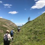
 CCWC hikes are free; however there are costs to coordinate and produce the hiking program and donations are always appreciated. Let your friends know, and bring them along to introduce them to the area. Be prepared for mountain conditions, and to be flexible due to bear encounters, trail closures, or poor weather. Please leave your pets at home. For more information and to confirm the hike meeting time and place contact the hike leader directly prior to the weekend of the hike. Some hikes require bikes for easy access at lower elevations. All hikers should be prepared to take full responsibility for their own health and safety. Due to snowpack some early hikes will be outside of the Castle. Please Note: It has become necessary to do the hikes as described in the brochure, and there will be no changes to a hike except in the case of bad weather or injury. The hike leader will pick someone to sweep the back of the group and no one is to hike ahead of the hike leader unless designated. Please check our Facebook page for updates to the hike schedule.
Click here to download a pdf of this year’s hike schedule.
May 27 – Prairie Bluff/Corner Mountain (South Ridge) 2258 m
Leader – Kevin Kelly – (403) 627-5128 The eastern edge of where the Castle Region meets the Prairies, this high point offers a great vantage point of the mountains to the south and west. We will look beyond the industrial activity in the eastern foreground to the prairie horizon. This route is off trail with a little route-finding and great rock scenery.
Elevation gain: 700 m Time: 6 hours Rating: moderate
June 3 – Big Sagebrush Hike
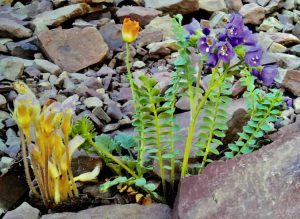 A short but steep grassland hike up to a rock band on Whistler Mountain in the South Castle Valley. A stewardship and wildflower hike in the
Big Sagebrush area. Several amazing wildflowers and rare plants will be looked for on our journey.
Hike Leader – Wendy Ryan 403-627-4106 Elevation Gain: 152 – 667 metres
Time: 6 hours
Rating: Moderate
June 24 – Horseshoe Basin
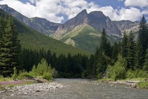
The trailhead for this Front Range hike begins at the far end of the bison paddock road on the north edge of Waterton Lakes National Park. Hikers may be treated to sights of woodland lily that often grow on the ascending slope found on the first section of trail. As we gain elevation, Waterton Lakes can be seen to the south. The trail then flattens out into a lovely open grassland valley with spectacular mountain headwall views. After crossing Galwey Creek, the trail continues northward up Horseshoe Basin. At the end of the valley, gentle switchbacks lead to the saddle straddling Horseshoe Basin and Oil Basin. We’ll enjoy open prairie vistas to the east and stunning mountain peaks to the west as we rest here for lunch. (If the creek is still high, water shoes are recommended.)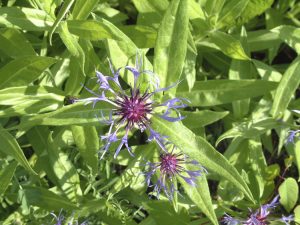
Please ensure you have appropriate clothing and gear and bring food & drinking water for your self.
Hike Leader – Susan Guerra 403.526.9415 call or text to register and find out meeting location/start area
Return trip: approx. 20 km
Time: approx. 6-7 hrs
Rating: Moderate
July 26 – Hike and Yoga
Join Karla Breeze of Shanti Hollow Yoga and Retreat for a hike to Carbondale Lookout (tentative hike location) this is an easy hike with some yoga along the way and at the top. Bring your own drinking water, snack/lunch and appropriate clothing. The yoga be for all levels and might be a nice way to introduce you to the practice of yoga. Contact office@ccwc.ab.ca for further information or to register.
Window Mountain Lake – RESCHEDULED to July 22
A half-day hike north of Crowsnest Mountain, this is a moderate, 4 km (round trip) hike to a beautiful mountain lake surrounded on three sides by huge cliffs, then an optional 2 km walk around it. We will have plenty of time at the lake, bring fishing gear if you wish. The spectacular feature is the “window” — a hole through one of the cliffs above the lake.
Hike Leader – Jay Allen 403-628-3048
Elevation gain: 150 metres
Time: 3 hrs
Rating: Moderate
August 10 – Front Canyon Reclamation Hike and Weed Pull – Blind Canyon
In conjunction with the Nature Conservancy of Canada we will, for a second year complete a weed pull at the old farm site in the canyon. Enjoy the beautiful scenery and learn about the history of the area. There will be a moderate hike of about 1 hour into the site. Packhorses will assist in removal of the weeds. Please contact Hike Leader – Wendy Ryan 403-627-4106 to register for this combined hike and weed pull.
August 12 - South Fork Lakes
Ford the West Castle River through knee-deep water. Bring water shoes to cross in. Hike up Barnaby Ridge on our improved switchback trail. Explore the three South Fork Lakes, enjoy stromatolites, larch covered slopes and vista views.
Hike Leader – Rob Bronson 403-978-5756
Elevation gain: 630 metres
Time: 7 hrs
Rating: Moderate
September 2 – Mount Haig (East Ridge) 2618 m
 Leader – Kevin Kelly (403) 627-5128 Straddling the BC/AB border this summit will quite literally take your breath away. The route we will take, which will avoid any elevation losses, follows the cat ski area ski-out road until it terminates just below a tarn (not Haig Lake). From here we still have 800 metres of elevation to gain up the east ridge on scree slopes and rock ledges. There is an option to traverse left on the east ridge and avoid all scrambling.
Elevation gain: 1200+ m Time: 8 hours Rating: strenuous/scramble
September 09 – Hike and Yoga
Join Karla Breeze of Shanti Hollow Yoga and Retreat for a hike to Carbondale Lookout (tentative hike location) this is an easy/gentle hike with some yoga along the way and at the top. Bring your own drinking water, snack/lunch and appropriate clothing. The yoga be for all levels and might be a nice way to introduce you to the practice of yoga. Contact office@ccwc.ab.ca for further information or to register.